

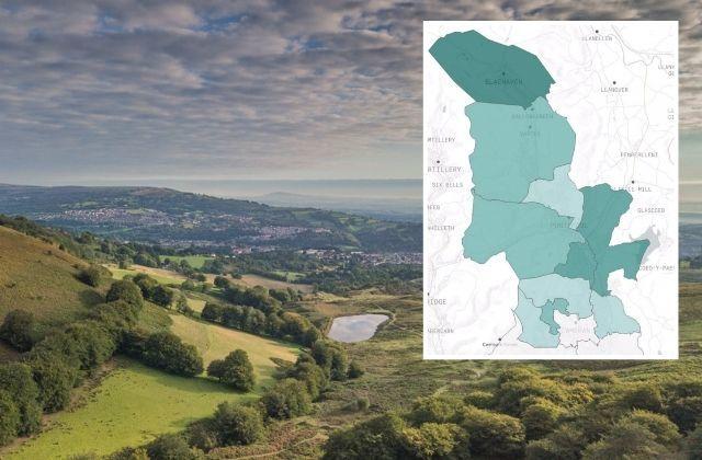

DATA on the density of new coronavirus cases over the past seven days has been released by Torfaen council.
The map shows that Blaenavon has the highest prevalence of new cases in the local authority.
The data comes from the council's Test, Track and Protect team over the seven days leading up to October 8.
READ MORE:
- Gwent regions under local coronavirus lockdown on right track - first minister
- Coronavirus: latest updates from Gwent as Mark Drakeford addresses the country
- 85 new coronavirus cases among 766 across Wales — here's where they are
The council said the bulk of transmission "is from families and friends meeting and mixing at home with people who are not part of their household."
Torfaen recorded 60 cases in the seven days covered by the latest Public Health Wales figures, although this figure covers September 30 to October 6, so does not line up exactly with the data from Torfaen council's Test, Track and Protect team.
The PHW figures put Torfaen at 63.9 cases per 100,000 population, above the 50 figure First Minister Mark Drakeford said needed to be consistently hit for local restrictions to be lifted.

A map showing the prevalence of Covid-19 cases around Torfaen. Picture: Torfaen council.
According to the data, New Inn and Panteg wards have the next highest number of new cases behind Blaenavon.
Abersychan, Pen Tranch (Pontnewynydd, Snatchwood, and Wainfelin wards), Pontymoile and Pontypool, as well as in the areas of Upper Cwmbran nearest the town centre account for a fairly high percentage of new cases, while Fairwater, the more rural areas of Upper Cwmbran, Pontnewydd, Trevethin, Crosyceiliog and Llanyravon account for a lower amount.
Henllys, Llantarnam, Ponthir and Central Cwmbran are the areas recording the lowest percentage of new cases over the past seven days.


Comments: Our rules
We want our comments to be a lively and valuable part of our community - a place where readers can debate and engage with the most important local issues. The ability to comment on our stories is a privilege, not a right, however, and that privilege may be withdrawn if it is abused or misused.
Please report any comments that break our rules.
Read the rules here