

MULTIPLE area of Newport and Gwent will be underwater in the near future, a climate change study has predicted.
The study has been conducted by Climate Central, an independent organisation of leading scientists and journalists who research climate change and its impact on the public.
The organisation used current projections to produce a map showing which areas of the country would be underwater by 2050.
The map shows that much of Newport will fall victim to rising sea levels if the projections are correct.
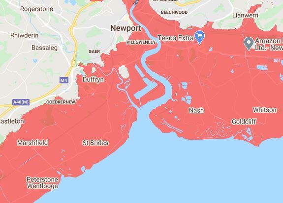
Maindee, Liswerry, Somerton and Pillgwenlly are all projected to be under water in the next 30 years by the study.
Nash, Duffryn and St Brides are also expected to be lost, as are many of the area near the banks of the River Usk.
It is a similar story further east in Monmouthshire.
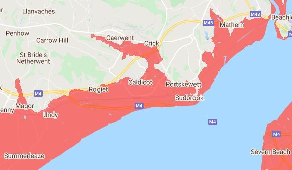
The projections show Magor, Undy and much of Caldicot being lost.
The impact is even seen as far north as Caerwent and Crick, which feel the effects of Nedern Brook overflowing.
The lower areas of Chepstow, near the banks of the River Wye are also projected to be unde rwater.
For the most part, areas north of the M4 are expected to be safe from the rising sea levels, but not all of them.
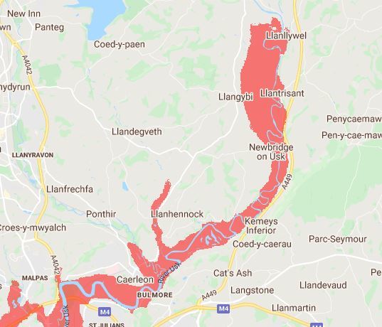
Due to their proximity to the River Usk, parts of Caerleon and Newbridge on Usk are expected to be lost.
And the impact is even felt as far north as Llanllywel.
Cardiff is expected to suffer similarly to Newport, with areas such as Leckwith, Pontcanna and Adamsdown finding themselves under water in 2050.
Climate Central admits the calculations that have led to fears of a nightmare scenario include "some error".
It says: "These maps incorporate big datasets, which always include some error. These maps should be regarded as screening tools to identify places that may require deeper investigation of risk."
The maps have been based on "global-scale datasets for elevation, tides and coastal flood likelihoods" and "imperfect data is used".
READ MORE:
- Coronavirus: A lockdown anniversary look back at a tumultuous 12 months
- Local lockdowns not ruled out if there's a Covid outbreak as Wales reopens
- Arsonist started fire after putting petrol-soaked Brillo pad in microwave
Somewhat comfortingly, Climate Central adds: "Our approach makes it easy to map any scenario quickly and reflects threats from permanent future sea-level rise well.
"However, the accuracy of these maps drops when assessing risks from extreme flood events.
"Our maps are not based on physical storm and flood simulations and do not take into account factors such as erosion, future changes in the frequency or intensity of storms, inland flooding, or contributions from rainfall or rivers."
But it adds: "Improved elevation data indicate far greater global threats from sea level rise and coastal flooding than previously thought, and thus greater benefits from reducing their causes."


Comments: Our rules
We want our comments to be a lively and valuable part of our community - a place where readers can debate and engage with the most important local issues. The ability to comment on our stories is a privilege, not a right, however, and that privilege may be withdrawn if it is abused or misused.
Please report any comments that break our rules.
Read the rules hereLast Updated:
Report this comment Cancel